Service & Utility Mapping

Utility and Service Investigations
Atlas Geophysical undertakes detailed utility location investigations using the combined techniques of active/passive electromagnetic prospecting and Ground Penetrating Radar (GPR).
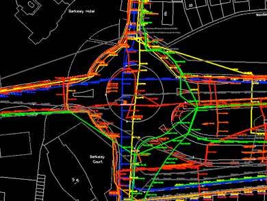
Radio Detection surveys cover large areas rapidly and provide concise spatial information regarding conductive utilities such as power cables, telecoms and water pipes. The information is marked on the ground surface and picked up by a topographic survey team for integration with GIS and CAD packages.
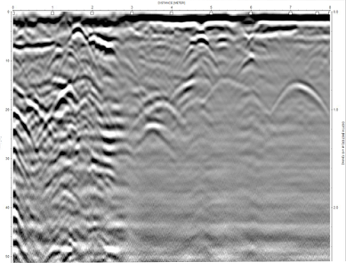
The GPR investigation follows on from the Radio Detection survey and compliments the technique by providing corroborative evidence of the utilities already located and fills in the gaps by locating non-conductive plastic pipes. An approximate depth to utilities can be derived from the GPR data. The GPR is geo-referenced with either RTK-GNSS or Differential GNSS enabling accurate data relocation.
Information regarding ground structure, voiding and relative moisture variation can be extracted from the GPR data using the latest analysis software.
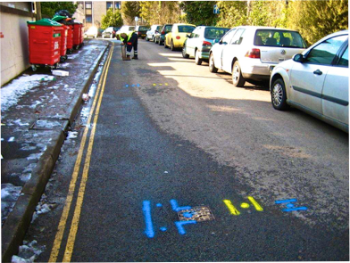
Reporting of utility location investigations is tailored to suite specific client needs. Often utility locations are marked on site to aid maintenance crews visualise the obstructions in their work area.
Large scale CAD plans and a full written report detailing the methodology and results are also issued.
IMPORTANT NOTE
It should be noted that GPR and EM techniques have their limitations.
It is not always possible to locate and trace every buried utility via non-destructive methods.
Scunthorpe (UK)
Oxford (UK)
Exeter (UK)
Typical subsurface utilities data showing hyperbolic response from buried pipes, ducts and cables.
Please do not copy/use our images
without our express permission.
Thanks.